GIS-Based Predictive Wetlands/Waters and Mitigation Modeling Tool
Texas Department of Transportation - Texas
Markets utiltized:
Keywords
Many of TxDOT’s state projects require wetland or stream mitigation that affect jurisdictional Waters of the United States (WOTUS). To offset these impacts, developers buy credits in a mitigation bank that holds the corresponding amount of land as conservation land. This conserved land must match the type of land impacted by the project and have credits available for purchase. Many State projects are either not located within the service area of a mitigation bank or the mitigation bank does not have the appropriate number or type of mitigation credits needed. Lack of available mitigation has resulted in project delays and unanticipated expenses. Currently, TxDOT does not have a mechanism to determine the amount and types of mitigation required for a project until WOTUS delineation and functional assessment(s) are conducted.
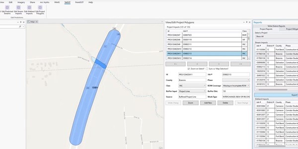
JMT is developing a GIS-based Predictive Wetlands/Waters and Mitigation Modeling Tool for use in future transportation projects. These tools use ArcGIS Pro, ArcHydro, and other geoprocessing tools to predict the amount and type of potentially jurisdictional wetlands and waters existing along transportation corridors where project impacts may occur. Currently, the focus is on two pilot HUC8s with development done in such a way to allow expansion statewide.
The Predictive Wetlands/Waters and Mitigation Modeling Tool will be used to determine the potential project impacts on the wetlands and streams within the project boundary, pre-process the data required for analysis, and determine which mitigation bank service areas the proposed impacts would occur within, and the estimated amount of mitigation required. The predictive wetland identification process will use ArcHydro Wetland Identification tools to build models that identify high-likelihood wetlands. The stream identification process will utilize ArcHydro Terrain Preprocessing tools to identify possible ephemeral streams utilizing available LIDAR-derived DEM data. The python tools will be wrapped in a custom add-in within ArcGIS Pro to provide a simplified user interface. This will allow users to intuitively access each step of the process, review the data inputs and predicted wetlands/waters features, and the identified matching mitigation bank service areas.

